This was a fun analysis— an update of Ken Cordell’s “Footprints on the Land” in which we intersected county-level projections of temperature change with models of population growth and land use change out to 2060 to identify areas where climate change may further complicate natural resources management. Once we’d identified these “Hotspots” using a technique called Local Indicators of Spatial Association (LISA), I overlaid T&E species and existing protected areas to show that these areas currently support high numbers of vulnerable and listed species and that the existing reserve network doesn’t provide much opportunity for communities to move, even in the West. Neelam Poudyal added a nice examination of the indicators of human community resiliency within and outside these hotspots that nicely complements the story on the natural communities.
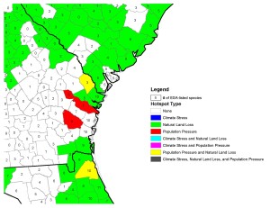
Folks have asked for zoomed-in maps of smaller areas such as the Georgia coast, shown below. I’m happy to provide these, though the T&E species data might be better from my current project, at least for freshwater aquatics. Citation is below. Snag it from the Land Use Policy website here, or drop me a line and I’ll send you a PDF.

Leave a Reply